Carbon Capture Storage: Remote Sensing, a Key Player
The Paris Agreement at COP21 pledged to limit the rise of global temperatures to well below 2°C, reminding us of the urgency of a transition to a low-carbon economy. With this objective, consolidated technologies that help mitigate gas emissions can play a pivotal role. A widespread adoption of carbon capture and storage (CCS), for instance, offers the opportunity to segregate CO2 emissions from large, stationary emitters, especially crucial for hard-to-abate sectors.
Carbon Capture and Storage (CCS) is a technique for trapping carbon dioxide (CO2) from large sources such as power plants, refineries, and factories. The carbon is compressed, dehydrated, and transported to a storage site, where it is injected into the ground in underground reservoirs such as depleted oil and gas reservoirs and deep saline caverns.
Despite being a mature technology, CCS adoption has been slow. This is primarily due to three factors: costs, policies, and confidence, which need to underpin the capital investments needed to build the infrastructures.
Some major policies may contribute to boosting investments, notably the Inflation Reduction Act (US) and the REPowerEU Plan with EU Green Deal Industrial Plan (Europe), but de-risking investments is still not at the same level as more developed green tech, such as Solar PV. These key areas of risk that investors look for maturity are off-take (stakeholder buy-in), technology (mature tech = reasonable deployment cost), policy (land ownership rights, long-term storage liabilities, public safety/confidence) and selling into markets (molecules harder to sell, palatable costs for users and suppliers).
Aside from the US/EU policies mentioned, other promising and results-bearing initiatives supporting the take-up of CCS globally are the work from OGCI and BCG, which created a common platform for major O&G players to act as catalysts and promote research around CCS, including the identification of optimal locations and transport costs (off-take risk).
The centrality of the US and Europe in policy making and their capability of attracting investments now make them the primary markets for key CCS implementations and, therefore, at the forefront of fundamental research.
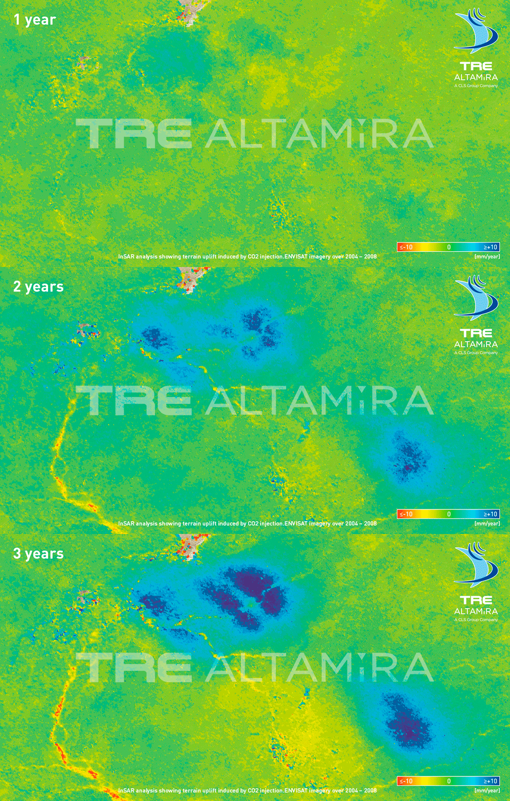
Our friends at TRE ALTAMIRA have been leveraging their InSAR technology to monitor the possible reactivation of faults/fractures and to track the pressure field variation associated with the CO2 injection into the Algerian subsurface in collaboration with In-Salah Gas Fields. This is a great example of how remote sensing tech can support the transition to a low-carbon economy by building evidence to support Policy risk and raise confidence in the role of CCS.
InSAR analysis showing terrain uplift induced by CO2 injection over a 3 year period. Credit: Tre Altamira
The challenges to be addressed with CCS are the monitoring during the injection phase, long-term storage security of the gas, and the full suitability of natural storage for CO2 sequestration.
The team at TRE ALTAMIRA used Interferometric Synthetic Aperture Radar (InSAR), a technique using radar satellites in space to collect ground measurement data over time. The time series are then analysed to calculate and predict ground movement or deformation. The use of InSAR, therefore, may present an opportunity to better understand optimal operations for injection location, monitoring operations, and safety, including leakage monitoring during post-implementation phases. Therefore, InSAR can provide a large amount of data and information and is a complementary technology to other geophysical instruments and measurements, such as micro seismic and 4D seismic (time based).
These innovative applications of InSAR are a pioneering first in onshore CCS, well worth a more in-depth look.
To begin with, the CO2 from several gas fields was removed from the production stream and transported for storage c.2km underground in a deep saline formation, the carboniferous sandstone of the Krechba field.
Here, the performance of the field post-deposition was monitored to ensure the CO2 remained isolated from the atmosphere. This meant understanding the flow direction/speed, the fault/fracture aperture change, and the reservoir volume change. The project used a combination of remote sensing methods (geophysical, geochemical, and InSAR) to measure these. By providing quantitative data to support prediction and the technology to monitor, it enabled a view of understanding how the gas can be contained and avoid any leakages.
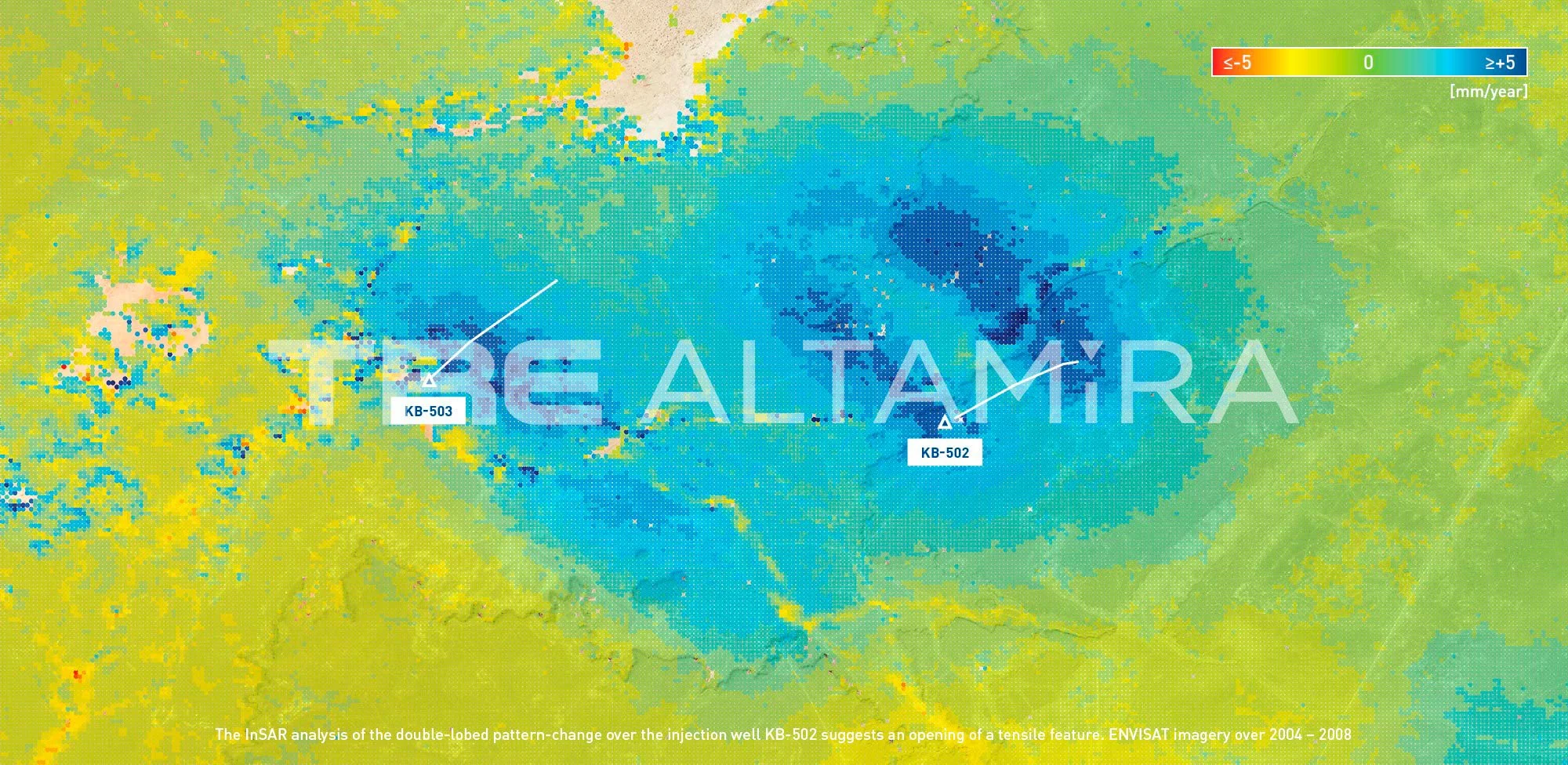
Archive InSAR data (Envisat at the ESA) was used to show historical patterns of how the ground surface was moving at the injection sites – this revealed a preferential flow of the CO2 and a suggested fracture opening 1.8km below the surface that supported the results of the seismic surveys of the fault/fracture. Vertical and horizontal surface displacement values from InSAR were then used to model the fault opening – this showed a good match between predicted and observed data and that an injected mass of 3 million tons of CO2 could result in a surface deformation of a few millimeters per year.
InSAR analysis demonstrating suggestion of a tensile feature. Credit: Tre Altamira
In conclusion, the use of InSAR enabled reservoir integrity (operational efficiency), reservoir model calibration (help manage isolation from the atmosphere) and active fault detection (support improved injection regimes and safety of surrounding areas).
What this may mean is that the use of this technology could address public and safety concerns and play a part in providing confidence to investors that can push adoption of CCS and speed up the energy transition.
For us here at Minesat, this is exciting in terms of delivering social value (e.g. UN SDGs) and even more exciting as it demonstrates the technical value of combining remote sensing and geospatial technologies and a solution with cost/value benefit too (the ratio of data coverage/data value/cost). With the opportunity for further development using InSAR and other pertinent technologies, think of drones, quantum geophysics and AI this could become a boon for the industry and our planet.
You can see the blog in full here and dive deeper into the technical paper here
For more information on CCS related to this article:
British Geological Society (BGS) explain the process this video and provide more information here
National Grid provide an overview


